JP
°F
測定値を変更する
Meters
Feet
摂氏
°F
時速キロメートル
時速マイル
ノット
am/pm
24-hour
設定が更新されました
言語を変更する
Deutsch
Español
Italiano
Nederlands
中文
English
Français
日本語
Português
今日
七日間
天気
釣り
海温
United States
潮見表
Georgia
潮見表
Camden County
潮見表
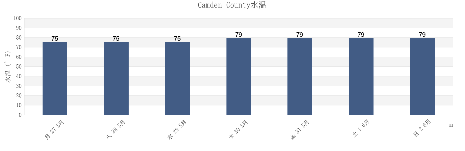
Camden Countyの海水温
今週のCamden Countyの海の温度
Camden Countyのより多くの潮汐と海洋情報
今日潮見表
今週潮見表
今週の天気
潮汐表 釣り
Camden County, Georgia, United Statesの地域
2.5 Miles Above Mouth
Fernandina Beach Amelia River
Main Beach
Bailey Cut (0.8 Mile West Of)
Fernandina Beach City Front Reach Amelia River
Old Fernandina Amelia River Old Town Reach
Bailey Cut 0 8 mile west of
Fernandina Pier
Quarantine Reach 0.4nm W of Fort Clinch
Bailey Cut Satilla River
Floyd Creek (2.8 Miles Above Entrance)
Raccoon Key Spit
Beach Creek Ent. (Cumberland Island)
Floyd Creek 2.8 Miles Above Entrance
Roses Bluff (Bells River)
Cabin Bluff Cumberland River
Fort Clinch 0.3 n.mi. N of
Roses Bluff Bells River
他の場所を表示
Ceylon
Fort Clinch 1.1 n.mi. NW of
Saint Marys
Chester (Bells River)
Harrietts Bluff (Crooked River)
Seacamp Dock (Cumberland Island)
Chester Bells River
Harrietts Bluff Crooked River
Seacamp Dock Cumberland Island
Comfort Inn/Jeckyll Island
Jekyll Creek south entrance
Seals
Comfort Inn/Jekyll Island
Jekyll Island Marina (Jekyll Creek)
south jetty
Crandall
Jekyll Island Marina Jekyll Creek
St Marys
Crooked River (Cumberland Dividings)
Jekyll Point, Jekyll Sound
St Marys Entrance North Jetty
Crooked River Cumberland Dividings
Kings Bay (Navy Base)
St. Marys
Cumberland Island Range B Channel
Kings Bay Base
St. Marys Entrance (North Jetty)
Cumberland River north entrance
Kings Bay Lower Turning Basin
St. Marys Entrance North Jetty
Cumberland Wharf (Cumberland River)
Kings Bay Navy Base
St. Marys River Entrance
Cumberland Wharf Cumberland River
Kings Bay NSB
Stafford Island west of
Cut 1 N Front Range St Marys River Entr
Kingsley Creek
Todd Creek Entrance
Dover Bluff (Dover Creek)
Kingsley Creek highway bridge
U S Highway 17
Dover Bluff Dover Creek
Kingsley Creek RR bridge
Drum Point Island Range D Channel
Little Satilla River
Camden County
Ceylon
Harrietts Bluff Crooked River
Harrietts Bluff (Crooked River)
Bailey Cut 0 8 mile west of
Bailey Cut (0.8 Mile West Of)
Bailey Cut Satilla River
Seals
Floyd Creek 2.8 Miles Above Entrance
Floyd Creek (2.8 Miles Above Entrance)
Cabin Bluff Cumberland River