JP
°F
測定値を変更する
Meters
Feet
摂氏
°F
時速キロメートル
時速マイル
ノット
am/pm
24-hour
設定が更新されました
言語を変更する
Deutsch
Español
Italiano
Nederlands
中文
English
Français
日本語
Português
今日
七日間
天気
釣り
海温
United States
潮見表
Virginia
潮見表
Accomack County
潮見表
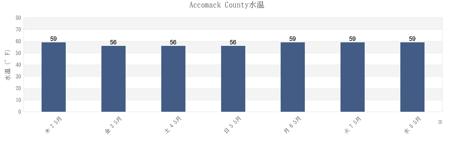
Accomack Countyの海水温
今週のAccomack Countyの海の温度
Accomack Countyのより多くの潮汐と海洋情報
今日潮見表
今週潮見表
今週の天気
潮汐表 釣り
Accomack County, Virginia, United Statesの地域
Accomac
Milby Point 5.3 n.mi. WNW of
Tangier Sound Light 5.8 n.mi. west of
Bluff Point 7.2 n.mi. east of
Muddy Creek Entrance
The Swash
Captains Cove
Nassawadox Point 1.9 n.mi. NW of
Upshur Neck (South End)
Chesconessex Creek (Schooner Bay)
Onancock
Upshur Neck South End
Chesconessex Creek Schooner Bay
Onancock (Onancock Creek)
Wachapreague
Chincoteague
Onancock Onancock Creek
Wachapreague Inlet (inside)
他の場所を表示
Folly Creek (Metompkin Inlet)
Pocomoke Sound Approach
Wachapreague Wachapreague Channel
Folly Creek Metompkin Inlet
Quinby Inlet entrance
Wallops Island
Gargathy Neck
Rappahannock Light
Watts Island
Gaskins Point (Occohannock Creek)
Revel Creek (Revel Island)
Watts Island 2.3 n.mi. east of
Gaskins Point Occohannock Creek
Revel Creek Revel Island
Watts Island 4 miles south of
Guard Shore
Stingray Point 12.5 miles east of
Wattsville
Harborton (Pungoteague Creek)
Tangier Island
Windmill Point Light 8.3 n.mi. ESE of
Harborton Pungoteague Creek
Tangier Sound Light 0.5 n.mi. east of
Metompkin Inlet
Tangier Sound Light 1.5 miles NE of
Accomack County
Chesconessex Creek Schooner Bay
Chesconessex Creek (Schooner Bay)
Onancock Onancock Creek
Onancock
Onancock (Onancock Creek)
Watts Island 2.3 n.mi. east of
Accomac
Guard Shore
Muddy Creek Entrance
Watts Island