JP
°F
測定値を変更する
Meters
Feet
摂氏
°F
時速キロメートル
時速マイル
ノット
am/pm
24-hour
設定が更新されました
言語を変更する
Deutsch
Español
Italiano
Nederlands
中文
English
Français
日本語
Português
今日
七日間
天気
釣り
海温
United States
潮見表
North Carolina
潮見表
Carteret County
潮見表
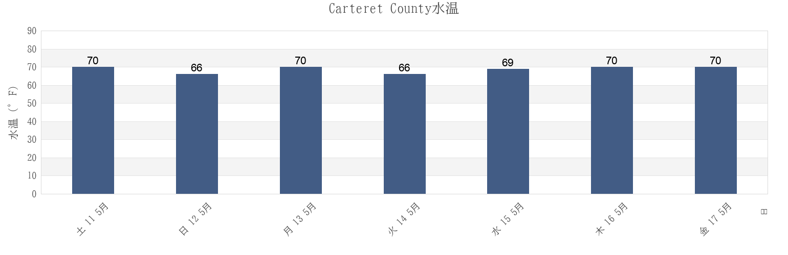
Carteret Countyの海水温
今週のCarteret Countyの海の温度
Carteret Countyのより多くの潮汐と海洋情報
今日潮見表
今週潮見表
今週の天気
潮汐表 釣り
Carteret County, North Carolina, United Statesの地域
Approach
Fort Macon (Uscg Station)
North River Bridge
Atlantic Beach
Fort Macon 0.2 mile NE of
Pettiford Creek Bay
Atlantic Beach Bridge
Fort Macon 0.6 mile SE of
Pine Knoll Shores
Atlantic Beach Triple S Pier
Fort Macon Uscg Station
Portsmouth Island
Beaufort
Gallant Channel
Radio Island E of
Beaufort (Taylor Creek)
Harkers Island
Salter Path
他の場所を表示
Beaufort Inlet Channel Range
Harkers Island Bridge
Sea Level
Beaufort Taylor Creek
Indian Beach
Sea Level Core Sound
Bird Shoal SE of
Lenoxville Point
Shackleford Banks 0.8 mile S of
Broad Creek
Middle Marshes S of
Shackleford Point NE of
Cape Carteret
Money Island
Shell Point
Cape Lookout (ocean)
Morehead City
Shell Point (Harkers Island)
Cape Lookout Bight
Morehead City Harbor
Shell Point Harkers Island
Carrot Island
Morehead City RR. bridge N of
Spooner Creek
Cedar Point
Morehead City S of
Spooners Creek
Channel Marker Lt. 59
N C State Fisheries
Sugarloaf Island 0.2 mile S of
Coral Bay (Atlantic Beach)
N.c. State Fisheries
Tombstone Point 0.1 mile E of
Coral Bay Atlantic Beach
Newport
Triple Ess Marina (Bogue Sd.)
Core Creek Bridge
Newport Marshes E of
Triple Ess Marina Bogue Sd.
Core Sound
Newport Marshes SE of
Triple S Marina Bogue Sd
Emerald Isle
Newport River (yacht Club)
Turning Basin
Carteret County
Core Sound
North River Bridge
Core Creek Bridge
Sea Level Core Sound
Sea Level
Newport River (yacht Club)
Harkers Island Bridge
Lenoxville Point
Harkers Island
Newport Marshes E of