JP
°F
測定値を変更する
Meters
Feet
摂氏
°F
時速キロメートル
時速マイル
ノット
am/pm
24-hour
設定が更新されました
言語を変更する
Deutsch
Español
Italiano
Nederlands
中文
English
Français
日本語
Português
今日
七日間
天気
釣り
海温
United States
潮見表
New York
潮見表
Richmond County
潮見表
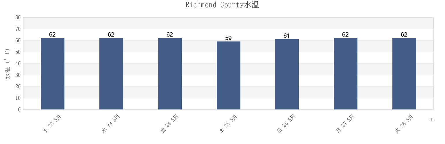
Richmond Countyの海水温
今週のRichmond Countyの海の温度
Richmond Countyのより多くの潮汐と海洋情報
今日潮見表
今週潮見表
今週の天気
潮汐表 釣り
Richmond County, New York, United Statesの地域
Ambrose Channel
Great Kills Park Staten Island
Sandy Hook (fort Hancock)
Bay Ridge west of
Hoffman Island 0.2 mile west of
Sandy Hook (Highlands)
Bay Street
Huguenot Beach
Sandy Hook Chan. 0.4 mi. W of N. Tip
Bayonne Bridge
Keansburg
Sandy Hook Channel
Bayonne Bridge Staten Island
Keansburg (Waackaack Creek)
Sandy Hook Pt. 2 mi. W of (channel)
Bergen Point East Reach
Midland Beach
Seguine Point
他の場所を表示
BERGEN POINT REACH (BAYONNE BRIDGE)
Midland Beach Staten Island
South Reach Newark Bay
Bergen Point West Reach
New Brighton
St George Staten Island
Big Spanish Key
New Dorp Beach 1.2 miles south of
St. George (Staten Island)
Bloomfield
Norton Point WSW of
St. George Staten Island
Chapel Hill South Channel
Old Orchard Shoal Lt. 1.2 mi. ENE of
Staten Island
Chelsea
Perth Amboy
The Cove
Compton Creek
Pews Creek
THE NARROWS midchannel
Coney Island Channel west end
Port Ivory
Tottenville Arthur Kill River
Coney Island Lt. 1.5 miles SSE of
Port Ivory Howland Hook
Tremley Point Reach
Constable Hook
Princes Bay
Tufts Point-Smoking Point
Elizabethport
Rahway River (Rr. Bridge)
Ward Point ESE
Fort Hamilton
Rahway River RR Bridge
Woodbridge Creek
Fort Hamilton The Narrows
Raritan Bay Reach Channel
Woodbridge Creek (0.8 N.mi. Above Entrance)
Fort Wadsworth
Red Bank 1.4 miles south of
Woodbridge Creek 0.8 N.Mi. Above Entrance
Fort Wadsworth The Narrows
Rossville
Great Kills Harbor
Sandy Hook
Richmond County
Staten Island
Bloomfield
Great Kills Park Staten Island
Great Kills Harbor
Chelsea
Tremley Point Reach
Midland Beach Staten Island
Bergen Point West Reach
Bayonne Bridge Staten Island
Midland Beach