JP
°F
測定値を変更する
Meters
Feet
摂氏
°F
時速キロメートル
時速マイル
ノット
am/pm
24-hour
設定が更新されました
言語を変更する
Deutsch
Español
Italiano
Nederlands
中文
English
Français
日本語
Português
今日
七日間
天気
釣り
海温
United States
潮見表
Maryland
潮見表
Somerset County
潮見表
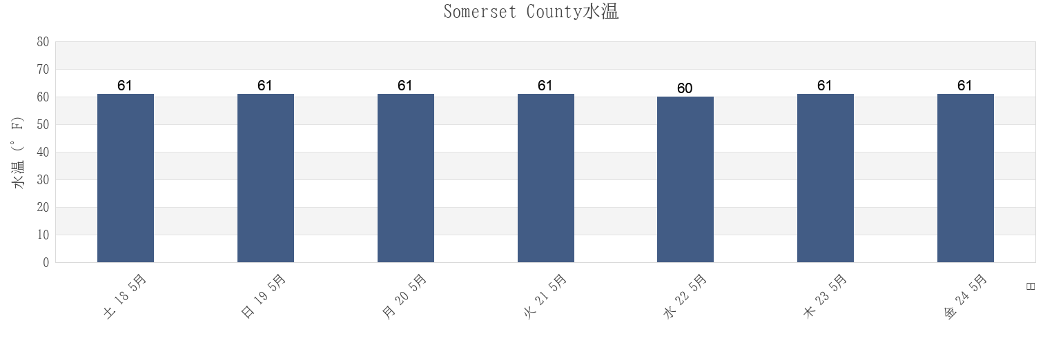
Somerset Countyの海水温
今週のSomerset Countyの海の温度
Somerset Countyのより多くの潮汐と海洋情報
今日潮見表
今週潮見表
今週の天気
潮汐表 釣り
Somerset County, Maryland, United Statesの地域
Ape Hole Creek (Pocomoke Sound)
Ewell Smith Island
Pocomoke R. 0.5 mile below Shelltown
Ape Hole Creek Pocomoke Sound
Fishing Bay Entrance at Buoy 2
Princess Anne
Big Annemessex River Entrance
Frog Point 1.6 miles south of
Raccoon Point
Bishops Head
Great Shoals Light (Monie Bay)
Roaring Point
Bishops Head Hooper Strait
Great Shoals Light Monie Bay
Roaring Point WSW of Nanticoke River
Chance
Holland Island Bar Light
Sandy Point Nanticoke River
他の場所を表示
Clump Island 2.5 n.mi. west of
Hooper Strait at Buoy 4
Saxis (Starling Creek Pocomoke Sound)
Colburn Creek (Big Annemessex River)
Janes Island Light 2.3 n.mi. NNE OF
Saxis Starling Creek Pocomoke Sound
Crisfield
Kedges Strait Buoy '4'
Sharkfin Shoal Light
Crisfield (Little Annemessex River)
Kedges Strait Buoy 4
Shelltown
Crisfield Little Annemessex River
Long Point (Big Annemessex River)
Smith Point Light 6.7 n.mi. east of
Dames Quarter Creek
Long Point 2.0 n.mi. northeast of
Solomons Lump Light
Deal Is. 0.6 n.mi. W. of at Bouy 14
Long Point and Nanticoke Point between
Teague Creek (Manokin River)
Deal Island
Long Point Big Annemessex River
Teague Creek Manokin River
Ewell (Smith Island)
Manokin R. Ent. 1.1 n.mi. E of Drum Pt
Victor Point 0.8 mile southwest of
Somerset County
Teague Creek (Manokin River)
Big Annemessex River Entrance
Teague Creek Manokin River
Manokin R. Ent. 1.1 n.mi. E of Drum Pt
Long Point Big Annemessex River
Long Point (Big Annemessex River)
Colburn Creek (Big Annemessex River)
Raccoon Point
Janes Island Light 2.3 n.mi. NNE OF
Deal Island