JP
°F
測定値を変更する
Meters
Feet
摂氏
°F
時速キロメートル
時速マイル
ノット
am/pm
24-hour
設定が更新されました
言語を変更する
Deutsch
Español
Italiano
Nederlands
中文
English
Français
日本語
Português
今日
七日間
天気
釣り
海温
United States
潮見表
Maine
潮見表
Sagadahoc County
潮見表
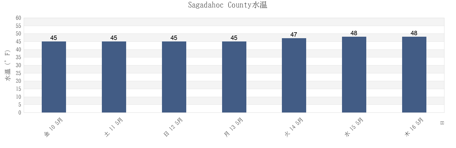
Sagadahoc Countyの海水温
今週のSagadahoc Countyの海の温度
Sagadahoc Countyのより多くの潮汐と海洋情報
今日潮見表
今週潮見表
今週の天気
潮汐表 釣り
Sagadahoc County, Maine, United Statesの地域
Androscoggin River Entrance
Fiddler Ledge north of
Pemaquid Harbor (Johns Bay)
Arrowsic Island
Fort Popham Hunniwell Point
Pemaquid Harbor Johns Bay
Back River
Goose Cove south of Chops Passage Kennebec River
Phippsburg
Bald Head 0.3 mile southwest of
Harpswell Harbor
Popham Beach
Bath
Howard Point (New Meadows River)
Popham Read
Bath Iron Works Kennebec River
Howard Point New Meadows River
Reid State Park
他の場所を表示
Bluff Head west of
Hunniwell Point
Robinhood (Sasanoa River)
Boothbay Harbor
Hunniwell Point northeast of
Robinhood Sasanoa River
Bowdoinham (Cathance River)
Isle Of Springs
Sheepscot River off Barter Island
Bowdoinham Cathance River
Lincoln Ledge east of
Small Point Harbor
Brunswick (Androscoggin River)
Little Flying Point
South Harpswell (Potts Harbor)
Brunswick Androscoggin River
Lowe Point (northeast of)
South Harpswell Potts Harbor
Carleton Ledges
Lowe Point NE of Sasanoa River
Southport (Townsend Gut)
Cross River Entrance
Lowell Cove, Orrs Island
Southport Townsend Gut
Cundy Harbor (New Meadows River)
Lower Hell Gate Knubble Bay
Sturgeon Island (Merrymeeting Bay)
Cundy Harbor New Meadows River
Merrymeeting Bay N of Chops Pass. Kennebec River
Sturgeon Island Merrymeeting Bay
Damariscotta River off Cavis Point
Mill Point (Sasanoa River)
Topsham
Damariscove Harbor (Damariscove Island)
Mill Point Sasanoa River
Upper Hell Gate Sasanoa River
Damariscove Harbor Damariscove Island
Monhegan Island
Wilson Cove
Doubling Point south of
New Harbor (Muscongus Bay)
Wilson Cove (Middle Bay)
Eagle Island W. of. Broad Sound
New Harbor Muscongus Bay
Wilson Cove Middle Bay
East Boothbay
North Bath
Woolwich
Sagadahoc County
Bath
Bath Iron Works Kennebec River
Lincoln Ledge east of
Woolwich
North Bath
Howard Point New Meadows River
Howard Point (New Meadows River)
Doubling Point south of
Thomas Point Beach
Carleton Ledges