Washington County, Rhode Island, United States潮位

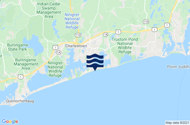
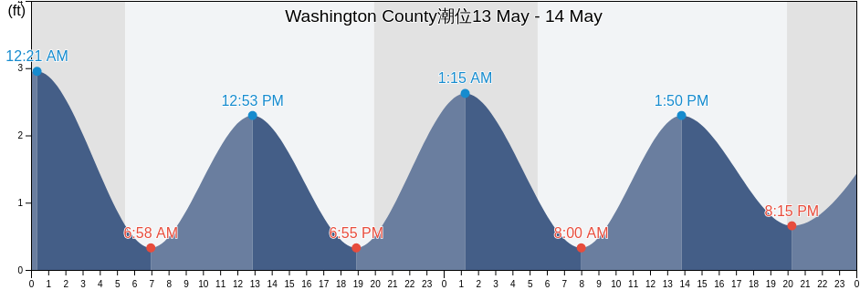
土曜日 20 4月 2024, 00:03 EDT (GMT -0400). Washington Countyは現在引き潮です。潮汐表に見られるように、満潮の2.95ftは18:45の予定です。また干潮の0ftは00:52です。 今週のWashington County潮見表を見るにはここをクリックしてください.

次の満潮

次の満潮は
06:24

次の干潮

次の干潮は
00:52

Washington County満潮干潮

今週Washington County潮見表
Washington County満潮干潮 日の出と日の入り
1潮 2潮 3潮 4潮
土 2000:52
0 ft
06:24
2.62 ft
12:55
0 ft
18:45
2.95 ft
05:58 19:33
日 2101:26
0 ft
07:05
2.62 ft
13:22
0 ft
19:23
2.95 ft
05:57 19:34
月 2201:56
0 ft
07:44
2.62 ft
13:48
0 ft
20:01
3.28 ft
05:55 19:35
火 2302:25
0 ft
08:22
2.62 ft
14:13
0 ft
20:38
3.28 ft
05:54 19:36
水 2402:55
-0.33 ft
09:00
2.62 ft
14:40
0 ft
21:16
3.28 ft
05:52 19:37
木 2503:25
-0.33 ft
09:38
2.62 ft
15:09
0 ft
21:54
3.28 ft
05:51 19:38
金 2603:57
0 ft
10:18
2.62 ft
15:42
0 ft
22:35
3.28 ft
05:50 19:39

今日Washington Countyで釣りに行くのに最適な時期 平均的な釣り日

メジャーフィッシング

から03:00から05:00

反対側の月の通過 (月の北中)

から15:30から17:30

月の通過 (月の南中)

マイナーフィッシング

から04:10から05:10

月の入り

から16:00から17:00

月の出

ここをクリックして、1週間のWashington Countyの釣り時間を確認してください.

今のWashington Countyの天気

付近所々で雨

天気

付近所々で雨
雲量100%
気温

気温

46°F
最低41°F/最高50°F
風

時速6マイル
突風時速10マイル
湿度

湿度

92%
露点44°F

今週のWashington Countyの天気を見るにはここをクリックしてください

今日のWashington County気温

日は05:58に出る予定です。また日は19:33に沈む予定です。今日の日照時間は13時間と35分です。また今日の平均水温は48°Fです。現在の水温は44°Fです。また平均水温は44°Fです。

今日のWashington County天気予報
0 h 3 h 6 h 9 h 12 h 15 h 18 h 21 h 24 h
付近所々で雨霧軽い霧雨小雨軽い霧雨付近所々で雨付近所々で雨時々曇り快晴
46°F48°F49°F48°F49°F48°F49°F44°F40°F

今週のWashington Countyの天気を見るにはここをクリックしてください

Washington Countyのより多くの潮汐と海洋情報

Washington County, Rhode Island, United Statesの地域

2.4 miles southwest ofLake MontaukPoint Judith Harbor Of Refuge
4 miles north ofLewis Point 6.0 miles WNW ofPond entrance - Point Judith
Allen HarborLewis Pt. 1.0 mile southwest ofQuonochontaug Beach
AshawayLewis Pt. 1.5 miles west ofQuonochontaug Beach 1.1 miles S of
Atlantic TerraceLighthouse (Point Judith)Quonochontaug Beach 3.8 miles S of
Block Island (Great Salt Pond)Little Narragansett Bay entranceRichmond Island
Block Island (Old Harbor)Mansion BeachRoger Wheeler State Beach
Block Island (SW end), Block Island SoundMatunuck-Deep HoleSalty Brine State Beach
Block Island (West)Matunuck-The pointSandy Point 2.1 miles NNE of
Block Island East (New Shoreham)Misquamicut State BeachSandy Point 4.1 miles northwest of
BradfordMonahans DockSandy Pt. 1.5 miles north of
Cerberus Shoal 1.5 miles east ofMontaukScarborough State Beach
CharlestownMontauk Harbor EntranceShagwong Reef & Cerberus Shoal
Charlestown Breachway BeachMontauk Point - TurtlesSouthwest Ledge
Clay Head 1.2 miles ENE ofMontauk Point 1 mile northeast ofSouthwest Ledge 2.0 miles west of
Crescent BeachMontauk Point 1.2 miles east ofSouthwest Point Block Island
East Beach Ninigret Conservation AreaMontauk Point 5.4 miles NNE ofStonington
East Matunuck State BeachMoonstone BeachWakefield-Peacedale
East Pt. 4.1 miles S of Fishers IslandNapatree JettyWatch Hill Point
ExeterNapatree Point 0.7 mile southwest ofWatch Hill Point 2.2 miles east of
FortressNarragansett BeachWatch Hill Point 5.2 miles SSE of
Galilee Beach Club BeachNarragansett PierWatch Hill Point 5.3 n.mi. SE of
Great Salt Pond ent. 1 mile NW ofNarragansett Town BeachWeekapaug Point (Block Island Sound)
Great Salt Pond entranceNorth BarWeekapaug Point Block Island Sound
Green Hill Point 1.1 miles south ofNorth KingstownWesterly
Harbor of Refuge south entranceNorth Kingstown BeachWesterly (Pawcatuck River)
HopkintonNorth Pier (Narragansett)Westerly Pawcatuck River
K38/39Old Harbor Pt. 0.5 mile southeast ofWicopesset island NE of
KingstonPoint Judith (Harbor Of Refuge)