Chatham County, Georgia, United States潮位

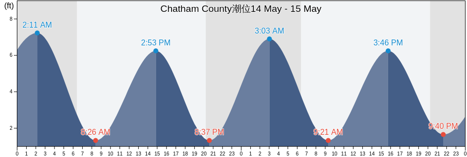
木曜日 25 4月 2024, 00:58 EDT (GMT -0400). Chatham Countyは現在引き潮です。潮汐表に見られるように、満潮の8.2ftは22:37の予定です。また干潮の0.33ftは04:29です。 今週のChatham County潮見表を見るにはここをクリックしてください.

次の満潮

次の満潮は
10:20

次の干潮

次の干潮は
04:29

Chatham County満潮干潮

今週Chatham County潮見表
Chatham County満潮干潮 日の出と日の入り
1潮 2潮 3潮 4潮
木 2504:29
0.33 ft
10:20
7.22 ft
16:23
0.33 ft
22:37
8.2 ft
06:44 20:01
金 2605:07
0.33 ft
10:56
6.89 ft
17:00
0.33 ft
23:13
8.2 ft
06:43 20:02
土 2705:47
0.33 ft
11:36
6.89 ft
17:40
0.66 ft
23:56
7.87 ft
06:42 20:02
日 2806:31
0.66 ft
12:24
6.56 ft
18:24
0.66 ft
06:41 20:03
月 2900:48
7.87 ft
07:19
0.66 ft
13:20
6.56 ft
19:16
0.66 ft
06:40 20:04
火 3001:48
7.55 ft
08:15
0.98 ft
14:22
6.56 ft
20:17
0.98 ft
06:39 20:04
水 102:52
7.55 ft
09:18
0.98 ft
15:25
6.89 ft
21:29
0.98 ft
06:38 20:05

今日Chatham Countyで釣りに行くのに最適な時期 良好な釣り日

メジャーフィッシング

から08:28から10:28

反対側の月の通過 (月の北中)

から20:59から22:59

月の通過 (月の南中)

マイナーフィッシング

から06:58から07:58

月の入り

から21:29から22:29

月の出

ここをクリックして、1週間のChatham Countyの釣り時間を確認してください.

今のChatham Countyの天気

時々曇り

天気

雲量42%
気温

気温

66°F
最低64°F/最高73°F
風

時速12マイル
突風時速21マイル
湿度

湿度

79%
露点59°F

今週のChatham Countyの天気を見るにはここをクリックしてください

今日のChatham County気温

日は06:44に出る予定です。また日は20:01に沈む予定です。今日の日照時間は13時間と17分です。また今日の平均水温は69°Fです。現在の水温は65°Fです。また平均水温は65°Fです。

今日のChatham County天気予報
0 h 3 h 6 h 9 h 12 h 15 h 18 h 21 h 24 h
時々曇り時々曇り時々曇り時々曇り時々曇り時々曇り時々曇り時々曇り時々曇り
66°F69°F69°F69°F73°F72°F69°F68°F67°F

今週のChatham Countyの天気を見るにはここをクリックしてください

Chatham Countyのより多くの潮汐と海洋情報

Chatham County, Georgia, United Statesの地域

2nd Street (Tybee Island)Fort Mcallister (Ogeechee River)Raccoon Key
610 Statute Mile MarkFort McAllister Ogeechee RiverRange A Light Bear River
Beach HammockFort PulaskiRomerly Marsh Creek
Bear River EntranceFort Pulaski 1.8 miles aboveS C L Rr Bridge
Bloody Point (Daufuskie Island)Fort Pulaski 4.8 miles aboveS.C.L. Rr. Bridge
Bloody Point Daufuskie IslandGood Hope Landing (South Of)Savannah
Bloody Pt. 0.5 mile north of New RiverGood Hope Landing South OfSavannah Bull Street
Bloody Pt. 0.5 mile west of New RiverGreys IslandSavannah River Entrance (between jetties)
Bradley Point (Bradley River)Hargray Pier (Daufuskie Island)Savannah River Entrance Fort Pulaski
Bradley Point Bradley RiverHargray Pier Daufuskie IslandSavannah Sheraton Resort Hotel
Bradley Point NNE ofHighway Bridge (Ogeechee River)Savannah southeast of highway bridge
Bull River 2 miles below hwy. bridgeHighway Bridge Ogeechee RiverSeaboard Coast Line Railroad
Burnside Island SE of Burnside RiverIsle of HopeSkidaway Island
Burntpot Island west of Skidaway RiverIsle of Hope (Skidaway River)Skidaway Island N End Wilmington River
Butter Bean BeachIsle of Hope City SE of Skidaway RiverSkidaway Narrows
Cane Patch Creek EntranceIsle of Hope City Skidaway RiverSkidaway River north entrance
Coffee Bluff (Forest River)Isle Of Hope Skidaway RiverSouth Channel western end
Coffee Bluff Forest RiverJoe's CutSouth of Kilkenny Creek Entrance
Cook Landing CemeteryJoes Cut Wilmington RiverSouth Ossabaw Island Bear River
Daufuskie Landing (Daufuskie Island)Kilkenny Club (Kilkenny Creek)St. Catherines Sound Entrance
Daufuskie Landing Daufuskie IslandKilkenny Club Kilkenny CreekThunderbolt
Daufuskie Landing Light south ofKing Island west ofThunderbolt SE of Wilmington River
Delegal Creek MarinaKings Island Channel Savannah RiverTurnbridge Landing (Salt Water Creek)
Doughboy IslandLazaretto Creek Entrance N of Bull RiverTurnbridge Landing Salt Water Creek
Dutch Island SE of Skidaway RiverLittle Back River Hwy. 17 Back River S.C.Tybee Creek Entrance
Egg IslandsLittle Don Island east of Vernon RiverTybee Island
Elba Island Cut NE of Savannah RiverLittle Ogeechee River EntranceTybee Light
Elba Island NE of Savannah RiverLittle Ogeechee River Entrance north ofTybee South End Sand Bar
Elba Island west of Savannah RiverLittle Wassaw Island SW ofVernon R. 1.2 miles S of Possum Point
Entrance off Beach HammockLong Island NNE of Skidaway RiverVernon View
Entrance off Wassaw IslandLong Island south of Skidaway RiverVernon View (Burnside River)
Fields Cut (Wright River)McQueen Island CutWalls Cut Turtle Island
Fields Cut Wright RiverMontgomeryWassaw Island N of E end Wassaw Sound
Fig Island north of Back RiverMontgomery Vernon RiverWassaw Island SSW of
Florida Passage (Bear River)North EntranceWhitemarsh Island
Florida Passage (Ogeechee River)North of Big Tom Creek EntranceWilmington Island
Florida Passage (south)Northwest of Newell Creek EntranceWilmington Island SSE of Bull River
Florida Passage Bear RiverOatland Island north tipWilmington R. 0.5 mi. S of Turners Creek
Florida Passage N of Ogeechee RiverOdingsell River EntranceWilmington R. ent. south channel
Florida Passage Ogeechee RiverPelican PointWilmington River ent. off Cabbage Island
Fort JacksonPigeon Island SSE of Skidaway RiverWright R. 0.2 mile above Walls Cut
Fort Mc Allister Ogeechee RiverPort Wentworth 0.2 mile above